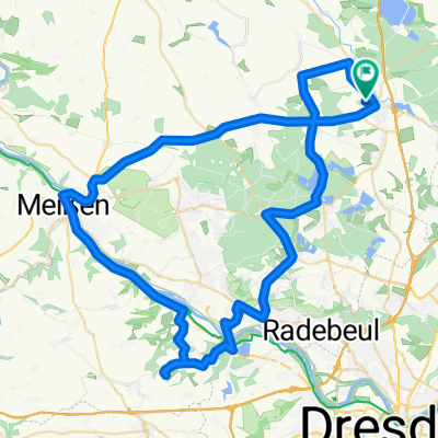
- 24.3 km
- 109 m
- 111 m
- Radeburg, Saxony, Germany
Von Radeburg nach Radebeul S-Bahnhof Ost
A cycling route starting in Radeburg, Saxony, Germany.
Overview
About this route
Mit der Lößnitzgrundbahn von Radebeul nach Radeburg fahren. Und dann mit den Rädern zum Großteil dem Zilleradweg folgen. Zu Beginn viel Asphalt, dann ein paar Feldwege und später noch Waldwege.
Eine Strecke für die ganze Familie, da die Steigungen moderat und nicht sehr lang sind. Highlights unterwegs sind das Wildgehege und das Schloss Moritzburg. Straßenverkehr unterwegs ist kaum relevant, da fast immer auf Radwegen gefahren wird. Erst im Lößnitzgrund von Friedewald nach Radebeul wird es etwas belebter, aber es besteht vielleicht auch die Möglichkeit, den Wanderweg an der Lößnitz zu fahren.
Für Rennräder ist die Strecke nicht geeignet. Proviant muss nicht unbedingt mitgenommen werden, da es unterwegs genug Einkehrmöglichkeiten gibt.
- 2 h 12 min
- Duration
- 29.1 km
- Distance
- 115 m
- Ascent
- 150 m
- Descent
- 13.2 km/h
- Avg. speed
- ---
- Max. altitude
created this 5 years ago
Route photos
Route quality
Waytypes & surfaces along the route
Waytypes
Quiet road
14.8 km
(51 %)
Track
6.4 km
(22 %)
Surfaces
Paved
19.2 km
(66 %)
Unpaved
6.4 km
(22 %)
Asphalt
18.9 km
(65 %)
Gravel
3.8 km
(13 %)
Continue with Bikemap
Use, edit, or download this cycling route
You would like to ride Von Radeburg nach Radebeul S-Bahnhof Ost or customize it for your own trip? Here is what you can do with this Bikemap route:
Free features
- Save this route as favorite or in collections
- Copy & plan your own version of this route
- Sync your route with Garmin or Wahoo
Premium features
Free trial for 3 days, or one-time payment. More about Bikemap Premium.
- Navigate this route on iOS & Android
- Export a GPX / KML file of this route
- Create your custom printout (try it for free)
- Download this route for offline navigation
Discover more Premium features.
Get Bikemap PremiumFrom our community
Other popular routes starting in Radeburg
- Rödern
- Tour 37: Masochistenkompott
- 63.4 km
- 366 m
- 368 m
- Radeburg, Saxony, Germany
- um die Königsbrücker Heide
- 79.4 km
- 287 m
- 268 m
- Radeburg, Saxony, Germany
- Training - Stoppomat
- 70.4 km
- 401 m
- 401 m
- Radeburg, Saxony, Germany
- Sonntagsausfahrt 14.08.22
- 85.6 km
- 541 m
- 539 m
- Radeburg, Saxony, Germany
- Radeb-Zschorna-Radeb.
- 33.4 km
- 106 m
- 106 m
- Radeburg, Saxony, Germany
- Königsbrücker Heide-Runde
- 64.2 km
- 275 m
- 268 m
- Radeburg, Saxony, Germany
- Leichte Randsachsenroute.
- 66 km
- 267 m
- 251 m
- Radeburg, Saxony, Germany
Open it in the app


