Premium Badge Download on the App Store Get it on Google Play Turn-by-turn Navigation Offline Maps Bike Type Optimized Routing Premium Maps Custom Bike Computer Export Routes Route Previews Fall Detection Premium Support

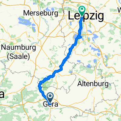
Cycling Route in Gera, Free State of Thuringia, Germany

Gera-Wünschendorf-Gera 16.3.2015

2
Open this route in the Bikemap app

Open this route in the Bikemap app

Open this route in Bikemap Web

Open this route in Bikemap Web

36 km
Distance
187 m
Ascent
187 m
Descent
-:-- h
Duration
-- km/h
Avg. Speed
--- m
Max. Elevation

About This Route

Alt-Bieblach-Gagarinstraße-Berliner str.-Zentrum-Reichstraße-Wintergarten-Pforten-Zwötzen-ERW-meilitz-ERW--Wünschendorf-bis Weidabrücke-Veitsberg-Chronschwitz-Wünschendorf-Meilitz-Kreisverkehr Liebschwitz-Salzstraße An der Elster bis Brücke Zwötzen-Ruckdeschelstraße -Zwötzner Str.-Stadion am Steg-Hinter dem Südbahnhof-heinrichsbrücke-Hofwiesenpark-Untermhaus-Schafwiesensiedlung-Franzosenbrücke-Siemensstraße-Industreistraße -Siemensstraße-Berlinerstraße-Str.des Bergmanns-J.R.becherstr.-Dr.-th.-Neubauerstraße

This cycling route is ideal for: Road bike

You will cycle on the following surfaces: Paved Unpaved

Customize this cycling route with the Bikemap route planner.

Make it yours!

Did you know? You can use this route as a template in our cycling route planner if you don't wish to start from scratch. Customize it based on your needs to plan your perfect cycling tour.

Open it in the app