Premium Badge Download on the App Store Get it on Google Play Turn-by-turn Navigation Offline Maps Bike Type Optimized Routing Premium Maps Custom Bike Computer Export Routes Route Previews Fall Detection Premium Support

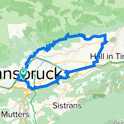
Cycling Route in Innsbruck, Tyrol, Austria

Patscherkofel Gipfelkreuz

3
Open this route in the Bikemap app

Open this route in the Bikemap app

Open this route in Bikemap Web

Open this route in Bikemap Web

24 km
Distance
1674 m
Ascent
23 m
Descent
-:-- h
Duration
-- km/h
Avg. Speed
--- m
Max. Elevation

About This Route

von Innsbruck aus beim Bretterkeller auf der Landstraße Richtung Igls, beim Elektrizitätswerk Vill abbiegen und der Straße Richtung Wald und zum Ende (Sackgasse) kurzes Schiebstück bis zum Golfplatz, dann über die Vogelhütte entlang der 6er Linie nach Igls - vorbei an der Seilbahn weiter zum Olympiaexpress der Landstraße Richtung Patsch - vor dem Grünwalderhof beginnt die Mountainbike Route zur Patscher Alm. Am Anfang steiler Forstweg, weiter zur Patscheralm - an der Alm vorbei weiter Richtung Patscherkofelhaus - vor dem Patscherkofelhaus direkt dem Weg weiter folgen bis zum Gipfel.

Wahnsinns Panorama der Zillertaler, Stubaier und zum Teil Ötztaler Alpen - Grandioser Rundumblick schon am Aufstieg zum Gipfel.

This cycling route is ideal for: MTB

You will cycle on the following surfaces: Paved Gravel

Customize this cycling route with the Bikemap route planner.

Make it yours!

Did you know? You can use this route as a template in our cycling route planner if you don't wish to start from scratch. Customize it based on your needs to plan your perfect cycling tour.

Open it in the app