Premium Badge Download on the App Store Get it on Google Play Turn-by-turn Navigation Offline Maps Bike Type Optimized Routing Premium Maps Custom Bike Computer Export Routes Route Previews Fall Detection Premium Support

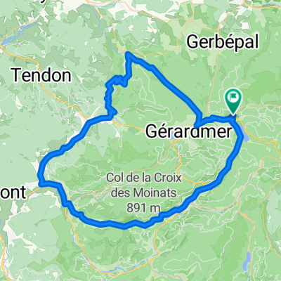
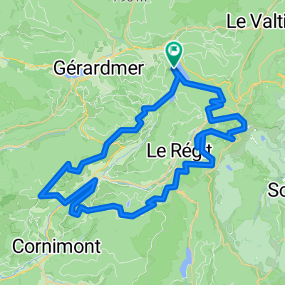
Cycling Route in Xonrupt-Longemer, Alsace-Champagne-Ardenne-Lorraine, France

2009 Euro Tour -- Ride Day 32 — 31 July 2009 — 88400 Xonrupt-Longemer — Circle

7
Open this route in the Bikemap app

Open this route in the Bikemap app

Open this route in Bikemap Web

Open this route in Bikemap Web

75 km
Distance
926 m
Ascent
926 m
Descent
-:-- h
Duration
-- km/h
Avg. Speed
--- m
Max. Elevation

About This Route

Despite efforts to get an early start, fortune just was not with us.
First, upon getting the bikes out of the hotel’s locked garage, we discovered my front tire was flat. (This was in addition to Helen’s having had several flats over the past several days due to, I think, faulty Performance patches.) I took a new tube to save time and found the valve stem was too short after getting everything together. Then when taking the wheel off again to put on another new tube, I unscrewed the quick release skewer too much so that the bolt fell off. While I found the bolt easily, the little metal spring was nowhere to be found. The son of the hotel owner first helped us look for the spring, then went to his bike, and gave us his spring as a “cadaux”. We sure appreciated his kindness. Now we were ready to start again…

…and we got as far as maybe 200 meters from the hotel. My left pedal had come apart due to a loose screw. I hustled back to the hotel on foot for my tools, fixed the pedal, and finally (two hours later than we’d intended) we were on our way for a very nice ride.

Today we rode north of D417 rather than south as we’d done yesterday. While the roads were much better from a traffic standpoint and there were clearly less tourists driving around, our route was easier from a climbing perspective since there were no healthy climbs to ski slopes like yesterday’s ride had had.  Very enjoyable ride, though, that would have been longer had we been able to start when we’d intended to.


This ride was entirely within the Vosges Department in the Lorraine Region.


Route:

Unnumbered road from just west of Auberge du Lac North to (not on Google Maps)

D23 Northeast past Col du Surcaneux (810 M) to

D73 North and unnumbered road into Fraize

D23 North past Col de Mandray (694 M) through Bertrimoutier to

D420 West to

D58 Southwest to Taintrux

D31 South to Corcieux

Unnumbered roads Southeast through Les Collieures and La-Basse-de-Martimpré (709 M) to

D8 South past Col de Martimpré (798 M) to

D417 East to Xonrupt-Longemer and Auberge du Lac


Background:

My wife and I have been doing self-supported tours in Western Europe (a majority in France) since 1993.  This series of rides covers our 2009 4.5 month route through parts of France, Germany, Austria, Switzerland, and then back to France.  Our beginning and ending point is near Chadurie (south of Angouleme) where our friends have a farm with Gites and Chambres d'Hotes.

We rode our Dawes touring bicycles purchased in 1993 heavily loaded with 700Cx32 tires.  All of our riding was on paved roads, mostly with very little traffic.  Pretty much the only unpaved sections were some bicycle paths in Germany and Austria. Sadly, that wasn't so great as Helen fell a number of times on the unpaved paths.  Fortunately, though, no serious injury.

If any questions, feel free to email me at jeffkadet@netdiving.com

Jeff

This cycling route is ideal for: Road bike

You will cycle on the following surfaces: Paved

Customize this cycling route with the Bikemap route planner.

Make it yours!

Did you know? You can use this route as a template in our cycling route planner if you don't wish to start from scratch. Customize it based on your needs to plan your perfect cycling tour.

Open it in the app