
Lightsey Rd, Austin a W Cesar Chavez St, Austin
- 6.6 km
- 33 m
- 94 m
- Rollingwood, Texas, United States
A cycling route starting in Rollingwood, Texas, United States.
Overview
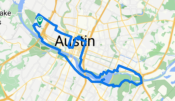
Being new to Austin, I got out for a short ride to explore a little around the lake. First, though, I rode by Rosen’s Bagels to buy a couple to see if they meet with my wife’s approval. Then, since I’d seen the dome of the state capitol while riding to the bagel place, I rode to it to see it up close. Nice well maintained building.
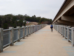
From the capitol, I rode down to the Colorado River (apparently also called Lady Bird Lake) and turned east to ride over a bike lane bridge to make a circle on the west side of the river. In some places I used the hard-pack dirt path while in others I used paved roads and bike lanes parallel to the edge of the river. The section of unpaved trail just after the cycling bridge at the east end was a couple miles of less than hard-pack trail. Passable, but many road riders would be less than excited by this portion.
For the most part, this was a nice ride along and near to the river, though for a good portion of the ride on the south side I was on East and West Riverside Dr, which was marked as a bike route on the map, but which clearly shouldn't have been. It had a lot of traffic and no shoulder. I suggest that you use other roads or the bike path along this section. My guess is that the bike path would be hard-pack, but I haven't yet ridden it to see.
Getting back to the pedestrian/biking bridge near city center, I crossed over and used the hard-packed path to get near to the HEB at the west end of my circle for some shopping.
created this 11 months ago


Route quality
Quiet road
6.5 km
(21 %)
Cycleway
6.5 km
(21 %)
Paved
20.3 km
(65 %)
Unpaved
4.7 km
(15 %)
Asphalt
15.9 km
(51 %)
Loose gravel
3.7 km
(12 %)
Continue with Bikemap
You would like to ride Austin - Circle Exploring Capitol and River or customize it for your own trip? Here is what you can do with this Bikemap route:
Free trial for 3 days, or one-time payment. More about Bikemap Premium.
Discover more Premium features.
Get Bikemap PremiumFrom our community
Open it in the app