
Quick ride by bicycle from Palo Alto to Mountain View
Customize your own route based on our template or discover how our community prefers to cycle from Palo Alto to Mountain View.
Route template
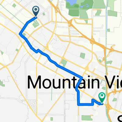
Palo Alto to Mountain View

- 39 min
- Duration
- 11.6 km
- Distance
- 30 m
- Ascent
- 6 m
- Descent
- 17.9 km/h
- Avg. speed
- 34 m
- Max. altitude
Kick-off your journey from the tech-savvy hub of Palo Alto, home to Stanford University and an abundance of innovation and start-ups. As you pedal through the city with a delightful mix of residential scenery and lush trees, you'll soon reach the more laid-back vibes of Mountain View. The ride is about 11.5 kilometers long, mostly taking you through quiet roads, making it perfect for a peaceful yet refreshing cycling experience.
The route is mostly flat, with a gentle ascent of around 30 meters, so it’s pretty friendly for casual riders or anyone looking to just enjoy the surroundings. A notable 71% of the path is smooth asphalt, so you'll have a nice, easy ride. Just a heads up, about 28% of the surface aren't recorded, but nothing too tricky to handle.
As you cruise towards Mountain View, home to iconic tech giant Google and the iconic Computer History Museum, you'll find that the bustling city has plenty of charm with its cool cafes and serene parks. Enjoy the ride, and don't forget to take a breather and soak in the beautiful Bay Area scenery along the way!
Community
Top users in this region


From our community
The best bike routes from Palo Alto to Mountain View

Cycling route in Palo Alto, California, United States of America
- 8.5 km
- Distance
- 147 m
- Ascent
- 150 m
- Descent

La Honda - St. Creek
Cycling route in Palo Alto, California, United States of America
- 76.4 km
- Distance
- 1,035 m
- Ascent
- 1,035 m
- Descent

Stevens Creek from home 1 way
Cycling route in Palo Alto, California, United States of America
- 14.9 km
- Distance
- 44 m
- Ascent
- 0 m
- Descent

actual route
Cycling route in Palo Alto, California, United States of America
- 14.8 km
- Distance
- 34 m
- Ascent
- 19 m
- Descent

2450 Garcia Ave, Mountain View to 429 Nicholas Dr, Mountain View
Cycling route in Palo Alto, California, United States of America
- 9.1 km
- Distance
- 58 m
- Ascent
- 37 m
- Descent

To Nijima Market
Cycling route in Palo Alto, California, United States of America
- 9.4 km
- Distance
- 35 m
- Ascent
- 4 m
- Descent

1035 Alma St, Palo Alto to 1250 Shorebird Way, Mountain View
Cycling route in Palo Alto, California, United States of America
- 10.3 km
- Distance
- 7 m
- Ascent
- 17 m
- Descent

Morning Ride
Cycling route in Palo Alto, California, United States of America
- 20 km
- Distance
- 54 m
- Ascent
- 4 m
- Descent

2525 E Bayshore Rd, Palo Alto to San Francisco Bay Trail, Mountain View
Cycling route in Palo Alto, California, United States of America
- 8.1 km
- Distance
- 16 m
- Ascent
- 9 m
- Descent

2450 Garcia Ave, Mountain View to 1200 Dale Ave, Mountain View
Cycling route in Palo Alto, California, United States of America
- 9.1 km
- Distance
- 53 m
- Ascent
- 10 m
- Descent

Biking Jer and Roy
Cycling route in Palo Alto, California, United States of America
- 12.5 km
- Distance
- 30 m
- Ascent
- 6 m
- Descent

Shoreline Park Trail, Mountain View to 505 Central Ave, Mountain View
Cycling route in Palo Alto, California, United States of America
- 7.1 km
- Distance
- 26 m
- Ascent
- 10 m
- Descent
Discover more routes
 2450 Garcia Ave, Mountain View to 429 Nicholas Dr, Mountain View
- Distance
- 9.1 km
- Ascent
- 58 m
- Descent
- 37 m
- Location
- Palo Alto, California, United States of America
 To Nijima Market
- Distance
- 9.4 km
- Ascent
- 35 m
- Descent
- 4 m
- Location
- Palo Alto, California, United States of America
 1035 Alma St, Palo Alto to 1250 Shorebird Way, Mountain View
- Distance
- 10.3 km
- Ascent
- 7 m
- Descent
- 17 m
- Location
- Palo Alto, California, United States of America
 Morning Ride
- Distance
- 20 km
- Ascent
- 54 m
- Descent
- 4 m
- Location
- Palo Alto, California, United States of America
 2525 E Bayshore Rd, Palo Alto to San Francisco Bay Trail, Mountain View
- Distance
- 8.1 km
- Ascent
- 16 m
- Descent
- 9 m
- Location
- Palo Alto, California, United States of America
 2450 Garcia Ave, Mountain View to 1200 Dale Ave, Mountain View
- Distance
- 9.1 km
- Ascent
- 53 m
- Descent
- 10 m
- Location
- Palo Alto, California, United States of America
 Biking Jer and Roy
- Distance
- 12.5 km
- Ascent
- 30 m
- Descent
- 6 m
- Location
- Palo Alto, California, United States of America
 Shoreline Park Trail, Mountain View to 505 Central Ave, Mountain View
- Distance
- 7.1 km
- Ascent
- 26 m
- Descent
- 10 m
- Location
- Palo Alto, California, United States of America