
Quick ride by bicycle from Berkeley to Emeryville
Customize your own route based on our template or discover how our community prefers to cycle from Berkeley to Emeryville.
Route template
Berkeley to Emeryville
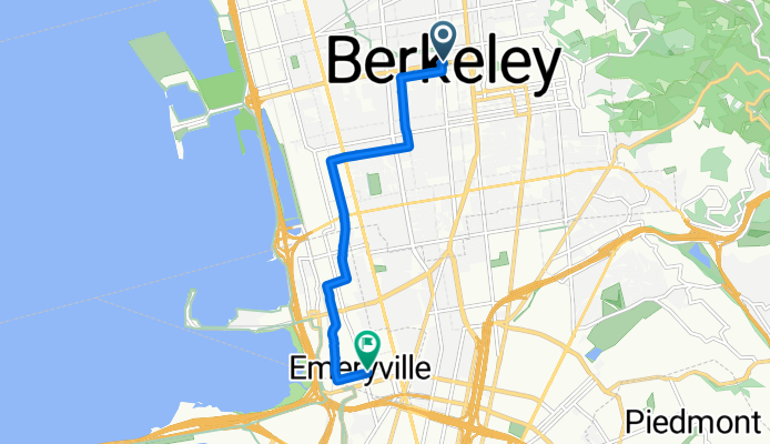
- 23 min
- Duration
- 6.9 km
- Distance
- 4 m
- Ascent
- 47 m
- Descent
- 18 km/h
- Avg. speed
- 52 m
- Max. altitude
Hey there, cycling enthusiast! Ready for a breezy ride from Berkeley to Emeryville? It's a leisurely 6.8-kilometer pedal that’ll take you through some cool parts of the East Bay.
You'll kick things off in Berkeley, a city bustling with students, intellectuals, and eclectic vibes thanks to the University of California, Berkeley. Known for its progressive spirit, you might want to take in some of the quirky street art or sip a coffee near the campus before hitting the road.
The route primarily takes you along quiet roads and cycleways—perfect for those who prefer a more relaxing ride without the hustle and bustle of traffic. You'll gently descend about 47 meters along the way, which makes for an easy glide as you soak up the scenery.
As you roll into Emeryville, you're arriving in a city that’s small but big on charm. It’s famous for housing Pixar Animation Studios, so who knows, you might catch a glimpse of some animation magic vibes in the air.
Enjoy the mix of urban and suburban landscapes, and maybe wrap things up with a stroll through Bay Street Emeryville for some shopping or a bite to eat! Happy cycling!
Community
Top users in this region


From our community
The best bike routes from Berkeley to Emeryville

college/bancroft <--> san pablo/alcatraz
Cycling route in Berkeley, California, United States of America
- 5.2 km
- Distance
- 4 m
- Ascent
- 88 m
- Descent

Escape from Berkeley #1
Cycling route in Berkeley, California, United States of America
- 56 km
- Distance
- 925 m
- Ascent
- 1,011 m
- Descent

Centennial-El Toyonal-Lomas Cantadas
Cycling route in Berkeley, California, United States of America
- 34.1 km
- Distance
- 793 m
- Ascent
- 862 m
- Descent

groceries
Cycling route in Berkeley, California, United States of America
- 2.4 km
- Distance
- 7 m
- Ascent
- 38 m
- Descent

Berkeley - Oakland Chinatown
Cycling route in Berkeley, California, United States of America
- 11.3 km
- Distance
- 8 m
- Ascent
- 34 m
- Descent

Ironworks
Cycling route in Berkeley, California, United States of America
- 4.5 km
- Distance
- 0 m
- Ascent
- 76 m
- Descent

De Grant Street 2200, Berkeley à Potter Street 800, Berkeley
Cycling route in Berkeley, California, United States of America
- 3.4 km
- Distance
- 0 m
- Ascent
- 28 m
- Descent

1845–1849 University Ave, Berkeley to 874 58th St, Oakland
Cycling route in Berkeley, California, United States of America
- 54.8 km
- Distance
- 1,251 m
- Ascent
- 1,279 m
- Descent

The REAL way home
Cycling route in Berkeley, California, United States of America
- 7.7 km
- Distance
- 28 m
- Ascent
- 84 m
- Descent

Miles Recording Studio from Home
Cycling route in Berkeley, California, United States of America
- 3 km
- Distance
- 0 m
- Ascent
- 44 m
- Descent

South Dr, Berkeley to 4150 Webster St, Oakland
Cycling route in Berkeley, California, United States of America
- 5.7 km
- Distance
- 15 m
- Ascent
- 76 m
- Descent

1530 Milvia St, Berkeley to 5854 Hollis St, Emeryville
Cycling route in Berkeley, California, United States of America
- 6.6 km
- Distance
- 29 m
- Ascent
- 86 m
- Descent
Discover more routes
 Berkeley - Oakland Chinatown
- Distance
- 11.3 km
- Ascent
- 8 m
- Descent
- 34 m
- Location
- Berkeley, California, United States of America
 Ironworks
- Distance
- 4.5 km
- Ascent
- 0 m
- Descent
- 76 m
- Location
- Berkeley, California, United States of America
 De Grant Street 2200, Berkeley à Potter Street 800, Berkeley
- Distance
- 3.4 km
- Ascent
- 0 m
- Descent
- 28 m
- Location
- Berkeley, California, United States of America
 1845–1849 University Ave, Berkeley to 874 58th St, Oakland
- Distance
- 54.8 km
- Ascent
- 1,251 m
- Descent
- 1,279 m
- Location
- Berkeley, California, United States of America
 The REAL way home
- Distance
- 7.7 km
- Ascent
- 28 m
- Descent
- 84 m
- Location
- Berkeley, California, United States of America
 Miles Recording Studio from Home
- Distance
- 3 km
- Ascent
- 0 m
- Descent
- 44 m
- Location
- Berkeley, California, United States of America
 South Dr, Berkeley to 4150 Webster St, Oakland
- Distance
- 5.7 km
- Ascent
- 15 m
- Descent
- 76 m
- Location
- Berkeley, California, United States of America
 1530 Milvia St, Berkeley to 5854 Hollis St, Emeryville
- Distance
- 6.6 km
- Ascent
- 29 m
- Descent
- 86 m
- Location
- Berkeley, California, United States of America
Routes from Berkeley
Quick ride by bicycle from
Berkeley to Oakland