
Cycling day trip from Minneapolis to Saint Paul
Customize your own route based on our template or discover how our community prefers to cycle from Minneapolis to Saint Paul.
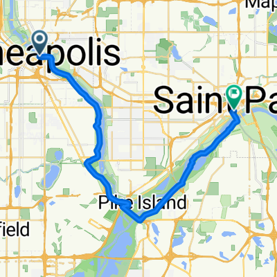
Route template
Minneapolis to Saint Paul

- 1 h 27 min
- Duration
- 25.5 km
- Distance
- 201 m
- Ascent
- 227 m
- Descent
- 17.6 km/h
- Avg. speed
- 259 m
- Max. altitude
Ready for a delightful ride between twin cities? Start off in the bustling urban hub of Minneapolis, known for its vibrant arts scene and beautiful lakes, and cycle your way over to the charming and historic Saint Paul. This route is a lovely 25.5 km journey mostly along dedicated cycleways, making it a safe and enjoyable trip for cyclists of all levels.
The course is smooth, with over 93% covered with asphalt and a bit of concrete thrown in, ensuring a comfortable ride. You’ll ascend about 200 meters and descend slightly more, so there will be some gentle hills to keep things interesting without being too challenging.
On your way, enjoy the transition between these two unique cities, through tree-lined paths and serene urban parks. Saint Paul, your destination, is packed with character and history. Make sure to explore its historic cathedrals and grab a coffee from one of its cozy cafés once you arrive.
This route is an excellent way to experience the best of both cities, while also enjoying the ride in between. Don’t forget your camera—both cities offer some great scenic shots! Happy cycling!
Community
Top users in this region


From our community
The best bike routes from Minneapolis to Saint Paul

Mississippi River Trail
Cycling route in Minneapolis, Minnesota, United States of America
- 47.3 km
- Distance
- 247 m
- Ascent
- 245 m
- Descent

B2B00865 55405>55102 via Greenway, Summit Av
Cycling route in Minneapolis, Minnesota, United States of America
- 19.9 km
- Distance
- 76 m
- Ascent
- 76 m
- Descent

B2B00204 55413>55102 via University & Como Ave
Cycling route in Minneapolis, Minnesota, United States of America
- 16.8 km
- Distance
- 83 m
- Ascent
- 103 m
- Descent

B2B00309 55401>55101 via University Av, Transitway, Como Ave
Cycling route in Minneapolis, Minnesota, United States of America
- 17.7 km
- Distance
- 106 m
- Ascent
- 105 m
- Descent

St. Paul
Cycling route in Minneapolis, Minnesota, United States of America
- 26.2 km
- Distance
- 168 m
- Ascent
- 172 m
- Descent

B2B00083 55403 > 55102 via Nicollet, Midtown Greenway, W. River Road, Lake/Marshall, Summit, Kellog Blvd., 7th St. W.
Cycling route in Minneapolis, Minnesota, United States of America
- 18.1 km
- Distance
- 44 m
- Ascent
- 52 m
- Descent

B2B 55413 > 55101 via East River Rd., Summit Ave.
Cycling route in Minneapolis, Minnesota, United States of America
- 19.2 km
- Distance
- 126 m
- Ascent
- 134 m
- Descent

B2B00761 55413>55102 via 8th Av SE, Como Av, Cedar St
Cycling route in Minneapolis, Minnesota, United States of America
- 17.6 km
- Distance
- 51 m
- Ascent
- 61 m
- Descent

B2B00762 55413>55101 via 8th St SE, Como Av
Cycling route in Minneapolis, Minnesota, United States of America
- 17.2 km
- Distance
- 53 m
- Ascent
- 46 m
- Descent

B2B00267 55401>55101via Hiawatha Trl, Greenway and Marshall Ave
Cycling route in Minneapolis, Minnesota, United States of America
- 16.3 km
- Distance
- 55 m
- Ascent
- 37 m
- Descent

B2B00881 55407>55102 via Greenway, Summit Av
Cycling route in Minneapolis, Minnesota, United States of America
- 15.2 km
- Distance
- 65 m
- Ascent
- 77 m
- Descent

B2B00448 55404 > 55102 via Pleasant, Greenway, Marshall
Cycling route in Minneapolis, Minnesota, United States of America
- 16 km
- Distance
- 43 m
- Ascent
- 21 m
- Descent
Discover more routes
 St. Paul
- Distance
- 26.2 km
- Ascent
- 168 m
- Descent
- 172 m
- Location
- Minneapolis, Minnesota, United States of America
 B2B00083 55403 > 55102 via Nicollet, Midtown Greenway, W. River Road, Lake/Marshall, Summit, Kellog Blvd., 7th St. W.
- Distance
- 18.1 km
- Ascent
- 44 m
- Descent
- 52 m
- Location
- Minneapolis, Minnesota, United States of America
 B2B 55413 > 55101 via East River Rd., Summit Ave.
- Distance
- 19.2 km
- Ascent
- 126 m
- Descent
- 134 m
- Location
- Minneapolis, Minnesota, United States of America
 B2B00761 55413>55102 via 8th Av SE, Como Av, Cedar St
- Distance
- 17.6 km
- Ascent
- 51 m
- Descent
- 61 m
- Location
- Minneapolis, Minnesota, United States of America
 B2B00762 55413>55101 via 8th St SE, Como Av
- Distance
- 17.2 km
- Ascent
- 53 m
- Descent
- 46 m
- Location
- Minneapolis, Minnesota, United States of America
 B2B00267 55401>55101via Hiawatha Trl, Greenway and Marshall Ave
- Distance
- 16.3 km
- Ascent
- 55 m
- Descent
- 37 m
- Location
- Minneapolis, Minnesota, United States of America
 B2B00881 55407>55102 via Greenway, Summit Av
- Distance
- 15.2 km
- Ascent
- 65 m
- Descent
- 77 m
- Location
- Minneapolis, Minnesota, United States of America
 B2B00448 55404 > 55102 via Pleasant, Greenway, Marshall
- Distance
- 16 km
- Ascent
- 43 m
- Descent
- 21 m
- Location
- Minneapolis, Minnesota, United States of America
Routes from Minneapolis
Cycling day trip from
Minneapolis to Richfield
Quick ride by bicycle from
Minneapolis to Saint Louis Park
Quick ride by bicycle from
Minneapolis to Falcon Heights