
Quick ride by bicycle from Hilpoltstein to Roth
Customize your own route based on our template or discover how our community prefers to cycle from Hilpoltstein to Roth.
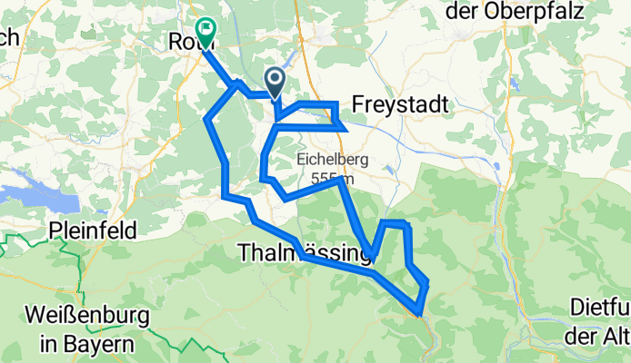
Route template
Hilpoltstein to Roth

- 53 min
- Duration
- 13.8 km
- Distance
- 82 m
- Ascent
- 122 m
- Descent
- 15.8 km/h
- Avg. speed
- 397 m
- Max. altitude
Hey there, cycling enthusiast! If you’re looking for an enjoyable ride, why not hop on your bike and pedal from Hilpoltstein to Roth? Here’s a little teaser of what to expect.
Starting off in Hilpoltstein, a charming little town known for its picturesque castle ruins, you'll immediately feel the fresh breeze and scenic views that this part of Bavaria offers. The route covers a distance of about 13.8 kilometers - perfect for a half-day adventure or a leisurely afternoon spin.
As you head out, you’ll mostly be riding on tracks and paths (about 46% and 31% respectively) with a good mix of gravel and asphalt surfaces - so make sure your tires are up for it! Along the way, expect gentle ascents and descents; the highest point you’ll hit is around 397 meters. It's all about enjoying the ride rather than conquering mountains on this route.
Arriving in Roth, you'll find a lively town that's famed for its annual triathlon and plenty of cozy spots to refuel and relax. Whether you're aiming to cycle back or hang around and explore, Roth is a great place to kick back.
Pack some water, maybe a snack, and definitely your sense of adventure. Happy cycling!
Community
Top users in this region

From our community
The best bike routes from Hilpoltstein to Roth

Rothsee-Traithlon Radstrecke
Cycling route in Hilpoltstein, Bavaria, Germany
- 41.1 km
- Distance
- 311 m
- Ascent
- 331 m
- Descent

Challenge Roth 2010 Aufzeichnung
Cycling route in Hilpoltstein, Bavaria, Germany
- 175.7 km
- Distance
- 742 m
- Ascent
- 768 m
- Descent

Challenge Roth
Cycling route in Hilpoltstein, Bavaria, Germany
- 178.8 km
- Distance
- 741 m
- Ascent
- 770 m
- Descent

DE_Roth Tri Total Trip
Cycling route in Hilpoltstein, Bavaria, Germany
- 100 km
- Distance
- 640 m
- Ascent
- 672 m
- Descent

Challenge Roth
Cycling route in Hilpoltstein, Bavaria, Germany
- 178.8 km
- Distance
- 731 m
- Ascent
- 762 m
- Descent

Radstrecke Challenge Roth_1
Cycling route in Hilpoltstein, Bavaria, Germany
- 178.3 km
- Distance
- 742 m
- Ascent
- 774 m
- Descent


Radstrecke Challenge Roth
Cycling route in Hilpoltstein, Bavaria, Germany
- 178.5 km
- Distance
- 1,665 m
- Ascent
- 1,693 m
- Descent

IM Roth bike
Cycling route in Hilpoltstein, Bavaria, Germany
- 178.4 km
- Distance
- 767 m
- Ascent
- 807 m
- Descent

Challenge Roth 2017
Cycling route in Hilpoltstein, Bavaria, Germany
- 178.3 km
- Distance
- 746 m
- Ascent
- 776 m
- Descent
DATEV Challenge Roth Bike Course 180km - DATEV Challenge Roth Bike Course 180km - 2023
Cycling route in Hilpoltstein, Bavaria, Germany
- 178 km
- Distance
- 1,765 m
- Ascent
- 1,790 m
- Descent

Am Rothsee 2, Hilpoltstein nach Straße ohne Straßennamen, Roth
Cycling route in Hilpoltstein, Bavaria, Germany
- 10.5 km
- Distance
- 16 m
- Ascent
- 25 m
- Descent
Discover more routes
 Challenge Roth
- Distance
- 178.8 km
- Ascent
- 731 m
- Descent
- 762 m
- Location
- Hilpoltstein, Bavaria, Germany
 Radstrecke Challenge Roth_1
- Distance
- 178.3 km
- Ascent
- 742 m
- Descent
- 774 m
- Location
- Hilpoltstein, Bavaria, Germany
 D-BY-Roth
- Distance
- 178.5 km
- Ascent
- 1,676 m
- Descent
- 1,692 m
- Location
- Hilpoltstein, Bavaria, Germany
 Radstrecke Challenge Roth
- Distance
- 178.5 km
- Ascent
- 1,665 m
- Descent
- 1,693 m
- Location
- Hilpoltstein, Bavaria, Germany
 IM Roth bike
- Distance
- 178.4 km
- Ascent
- 767 m
- Descent
- 807 m
- Location
- Hilpoltstein, Bavaria, Germany
 Challenge Roth 2017
- Distance
- 178.3 km
- Ascent
- 746 m
- Descent
- 776 m
- Location
- Hilpoltstein, Bavaria, Germany
 DATEV Challenge Roth Bike Course 180km - DATEV Challenge Roth Bike Course 180km - 2023
- Distance
- 178 km
- Ascent
- 1,765 m
- Descent
- 1,790 m
- Location
- Hilpoltstein, Bavaria, Germany
 Am Rothsee 2, Hilpoltstein nach Straße ohne Straßennamen, Roth
- Distance
- 10.5 km
- Ascent
- 16 m
- Descent
- 25 m
- Location
- Hilpoltstein, Bavaria, Germany