
Route template
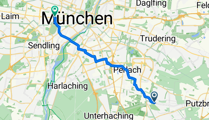
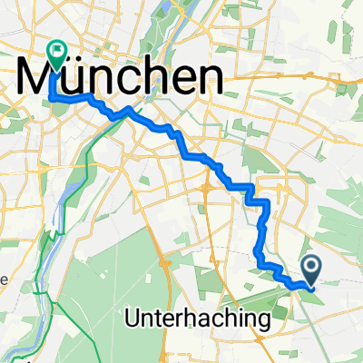
Neubiberg to Munich

- 45 min
- Duration
- 12.7 km
- Distance
- 39 m
- Ascent
- 62 m
- Descent
- 16.9 km/h
- Avg. speed
- 550 m
- Max. altitude
Start your cycling adventure in the lovely suburb of Neubiberg, known for its friendly community vibes and lovely green spaces. You’ll get to enjoy some peaceful path riding, which makes up a good part of your journey. With mostly asphalt surfaces under your wheels, you’ll have a smooth ride almost all the way.
As you pedal along the quiet roads, you’ll do a little bit of climbing with an ascent of 39 meters, but you’ll also enjoy the descent of 62 meters, which brings a nice breeze as you head towards Munich.
Once you reach Munich, the bustling capital of Bavaria, take some time to explore its rich history, stunning architecture, and of course, if the weather allows, enjoy a refreshing drink in one of its many beer gardens.
This leisurely ride covers around 12.7 kilometers—an enjoyable way to transition from the tranquility of Neubiberg to the lively streets of Munich. It’s a perfect little journey for a gentle workout or a weekend outing, so hop on your bike and enjoy the ride!
Community
Top users in this region


From our community
The best bike routes from Neubiberg to Munich

Nbb - Flugfeld -Perl. Forst - Zoo - Isar - Wittelsbach.Br. - PH
Cycling route in Neubiberg, Bavaria, Germany
- 17.1 km
- Distance
- 22 m
- Ascent
- 52 m
- Descent

Perlach - PH along quiet routes
Cycling route in Neubiberg, Bavaria, Germany
- 12.6 km
- Distance
- 13 m
- Ascent
- 29 m
- Descent

Neubiberg - Pschorr: Scenic Route
Cycling route in Neubiberg, Bavaria, Germany
- 16.7 km
- Distance
- 21 m
- Ascent
- 49 m
- Descent
Neubiberg .- Pschorr: Direct
Cycling route in Neubiberg, Bavaria, Germany
- 13 km
- Distance
- 14 m
- Ascent
- 43 m
- Descent

WP to PH1-4 - quick, short with nice parts.
Cycling route in Neubiberg, Bavaria, Germany
- 12.9 km
- Distance
- 8 m
- Ascent
- 34 m
- Descent

Neubiberg via ESM to ISAR and PH
Cycling route in Neubiberg, Bavaria, Germany
- 15.7 km
- Distance
- 14 m
- Ascent
- 42 m
- Descent

Neubiberg - PH via Zwergerstr. - Grosshesseloher Brücke
Cycling route in Neubiberg, Bavaria, Germany
- 21.8 km
- Distance
- 42 m
- Ascent
- 68 m
- Descent

Neubiberg - PH via Flugfeld - Grosshesseloher Brücke - Isartalbahn - Thalkirchen
Cycling route in Neubiberg, Bavaria, Germany
- 20.8 km
- Distance
- 44 m
- Ascent
- 70 m
- Descent

München - Passau - München
Cycling route in Neubiberg, Bavaria, Germany
- 428.7 km
- Distance
- 485 m
- Ascent
- 505 m
- Descent

Perlach - Peraloh - Görzer - Laibach - Balan - Gebsattel - Westermühl - Nussbaum - PH
Cycling route in Neubiberg, Bavaria, Germany
- 10.6 km
- Distance
- 15 m
- Ascent
- 35 m
- Descent

Nbb - PH via Zwerger - Leif - Giesing - Balde
Cycling route in Neubiberg, Bavaria, Germany
- 14.5 km
- Distance
- 9 m
- Ascent
- 40 m
- Descent

Nbb - Pschorr (via Zwergerlstr - Infineon - Perlacher Forst - Flaucher)
Cycling route in Neubiberg, Bavaria, Germany
- 16.3 km
- Distance
- 21 m
- Ascent
- 49 m
- Descent
Discover more routes
 WP to PH1-4 - quick, short with nice parts.
- Distance
- 12.9 km
- Ascent
- 8 m
- Descent
- 34 m
- Location
- Neubiberg, Bavaria, Germany
 Neubiberg via ESM to ISAR and PH
- Distance
- 15.7 km
- Ascent
- 14 m
- Descent
- 42 m
- Location
- Neubiberg, Bavaria, Germany
 Neubiberg - PH via Zwergerstr. - Grosshesseloher Brücke
- Distance
- 21.8 km
- Ascent
- 42 m
- Descent
- 68 m
- Location
- Neubiberg, Bavaria, Germany
 Neubiberg - PH via Flugfeld - Grosshesseloher Brücke - Isartalbahn - Thalkirchen
- Distance
- 20.8 km
- Ascent
- 44 m
- Descent
- 70 m
- Location
- Neubiberg, Bavaria, Germany
 München - Passau - München
- Distance
- 428.7 km
- Ascent
- 485 m
- Descent
- 505 m
- Location
- Neubiberg, Bavaria, Germany
 Perlach - Peraloh - Görzer - Laibach - Balan - Gebsattel - Westermühl - Nussbaum - PH
- Distance
- 10.6 km
- Ascent
- 15 m
- Descent
- 35 m
- Location
- Neubiberg, Bavaria, Germany
 Nbb - PH via Zwerger - Leif - Giesing - Balde
- Distance
- 14.5 km
- Ascent
- 9 m
- Descent
- 40 m
- Location
- Neubiberg, Bavaria, Germany
 Nbb - Pschorr (via Zwergerlstr - Infineon - Perlacher Forst - Flaucher)
- Distance
- 16.3 km
- Ascent
- 21 m
- Descent
- 49 m
- Location
- Neubiberg, Bavaria, Germany
Routes from Neubiberg
Quick ride by bicycle from
Neubiberg to Bogenhausen
Quick ride by bicycle from
Neubiberg to Unterhaching
Routes to Munich
Cycling day trip from
Bad Tölz to Munich
Cycling day trip from
Starnberg to Munich
Quick ride by bicycle from
Unterschleißheim to Munich
Quick ride by bicycle from
Garching bei München to Munich