
Route template
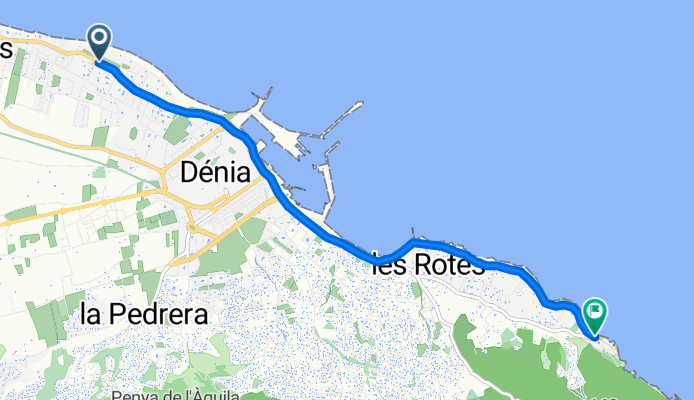
Denia to Xàbia

- 1 h 17 min
- Duration
- 21.9 km
- Distance
- 170 m
- Ascent
- 172 m
- Descent
- 16.9 km/h
- Avg. speed
- 121 m
- Max. altitude
Start your adventure in the charming coastal town of Denia, known for its stunning beaches and the picturesque Montgo Nature Reserve. Kick off your cycling journey through this beautiful region by heading towards Xàbia, a neighboring town that's no less captivating.
This leisurely 21.9-kilometer ride offers a great mix of terrain, with nearly two-thirds of your journey taking place on quiet roads, ideal for soaking in the scenic countryside views. The elevation change is moderate, so you’ll have a few ups and downs to keep things interesting. Plus, the elevation never pushes you over 121 meters, so it's gentle enough for most riders.
You'll be rolling along primarily on asphalt and paved surfaces, which makes for a pretty smooth ride. A small portion involves gravel and paving stones, adding a bit of variety under your wheels.
As you approach Xàbia, you'll find another beautiful coastal town brimming with its charming cobblestone streets and a stunning marina. Take a breather, grab a coffee at one of the local cafes, and if you have time, enjoy the stunning views from the Xàbia Promenade. This ride perfectly combines the joy of cycling with the best of Costa Blanca living. Enjoy!
Community
Top users in this region


From our community
The best bike routes from Denia to Xàbia


Cima del Montgo
Cycling route in Denia, Valencia, Spain
- 7.9 km
- Distance
- 776 m
- Ascent
- 669 m
- Descent


fun & quats - les rotes + subida torre del gerro
Cycling route in Denia, Valencia, Spain
- 10.2 km
- Distance
- 212 m
- Ascent
- 91 m
- Descent

Denia - Moraira (Casa Delfin Teulada)
Cycling route in Denia, Valencia, Spain
- 16.3 km
- Distance
- 147 m
- Ascent
- 132 m
- Descent
fun & quats - les rotes
Cycling route in Denia, Valencia, Spain
- 7.1 km
- Distance
- 63 m
- Ascent
- 50 m
- Descent

Por el Montgo - Denia
Cycling route in Denia, Valencia, Spain
- 7.5 km
- Distance
- 488 m
- Ascent
- 286 m
- Descent


Carrer Tritó, 12C, Dénia nach Carrer Caleta, 3A, Xàbia
Cycling route in Denia, Valencia, Spain
- 11.1 km
- Distance
- 254 m
- Ascent
- 260 m
- Descent

20150317_153829.gpx
Cycling route in Denia, Valencia, Spain
- 18.6 km
- Distance
- 197 m
- Ascent
- 197 m
- Descent

cami de la colonia
Cycling route in Denia, Valencia, Spain
- 5.5 km
- Distance
- 380 m
- Ascent
- 225 m
- Descent
Discover more routes
 Denia - Moraira (Casa Delfin Teulada)
- Distance
- 16.3 km
- Ascent
- 147 m
- Descent
- 132 m
- Location
- Denia, Valencia, Spain
 fun & quats - les rotes
- Distance
- 7.1 km
- Ascent
- 63 m
- Descent
- 50 m
- Location
- Denia, Valencia, Spain
 Por el Montgo - Denia
- Distance
- 7.5 km
- Ascent
- 488 m
- Descent
- 286 m
- Location
- Denia, Valencia, Spain
 Denia - Cabo San Antonio
- Distance
- 9.4 km
- Ascent
- 212 m
- Descent
- 32 m
- Location
- Denia, Valencia, Spain
 montaña cima
- Distance
- 9.1 km
- Ascent
- 684 m
- Descent
- 576 m
- Location
- Denia, Valencia, Spain
 Carrer Tritó, 12C, Dénia nach Carrer Caleta, 3A, Xàbia
- Distance
- 11.1 km
- Ascent
- 254 m
- Descent
- 260 m
- Location
- Denia, Valencia, Spain
 20150317_153829.gpx
- Distance
- 18.6 km
- Ascent
- 197 m
- Descent
- 197 m
- Location
- Denia, Valencia, Spain
 cami de la colonia
- Distance
- 5.5 km
- Ascent
- 380 m
- Descent
- 225 m
- Location
- Denia, Valencia, Spain
Routes from Denia
Cycling day trip from
Denia to Beniarrés