
Quick ride by bicycle from Mandaluyong City to Pasig
Customize your own route based on our template or discover how our community prefers to cycle from Mandaluyong City to Pasig.
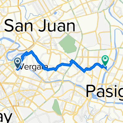
Route template
Mandaluyong City to Pasig

- 29 min
- Duration
- 6.4 km
- Distance
- 186 m
- Ascent
- 141 m
- Descent
- 13.1 km/h
- Avg. speed
- 94 m
- Max. altitude
Kick off your journey in the vibrant Mandaluyong City, often called the "Tiger City of the Philippines." Known for its bustling business district and shopping centers, Mandaluyong offers a great mix of urban life and local charm.
Your ride to Pasig covers just a little over 6 kilometers, which should take around an hour and 45 minutes to complete at a leisurely pace. Expect a pleasant mix of road types with 58% being quiet roads—perfect for soaking in the surroundings without the stress of heavy traffic.
Your route gently climbs and descends through the area, with the highest point reaching just shy of 95 meters. Along the way, you'll encounter a variety of surfaces, mostly asphalt, but also patches of concrete and paving stones, keeping it interesting under the tires.
As you cycle towards Pasig, popularly known as the "Green City," you'll feel the shift as you enter this part of Metro Manila. Once primarily an industrial hub, Pasig is now a blend of urban and green spaces, perfect for unwinding after your ride. Don’t miss the chance to check out the iconic Pasig Cathedral or explore the city’s thriving food scene. Enjoy the ride!
Community
Top users in this region


From our community
The best bike routes from Mandaluyong City to Pasig

Amarillo 803, Maynila to FMF Building, Pasig
Cycling route in Mandaluyong City, National Capital Region, Philippines
- 2.7 km
- Distance
- 39 m
- Ascent
- 38 m
- Descent

Maharlika 643, Mandaluyong to Meralco Avenue 10, Pasig
Cycling route in Mandaluyong City, National Capital Region, Philippines
- 4.5 km
- Distance
- 45 m
- Ascent
- 10 m
- Descent

Zobel Roxas Street 1439, Manila to Ortigas Avenue, San Juan
Cycling route in Mandaluyong City, National Capital Region, Philippines
- 7.6 km
- Distance
- 38 m
- Ascent
- 59 m
- Descent

Caimito 151, Makati to P.E. Antonio, Pasig
Cycling route in Mandaluyong City, National Capital Region, Philippines
- 6.5 km
- Distance
- 20 m
- Ascent
- 23 m
- Descent

Boni to Shaw
Cycling route in Mandaluyong City, National Capital Region, Philippines
- 1.1 km
- Distance
- 12 m
- Ascent
- 0 m
- Descent

Eloriaga 2421, Manila to Epifanio de los Santos Avenue Corner, Mandaluyong
Cycling route in Mandaluyong City, National Capital Region, Philippines
- 10.1 km
- Distance
- 72 m
- Ascent
- 40 m
- Descent

Maharlika 644, Mandaluyong to H3P7+R9F, Pasig
Cycling route in Mandaluyong City, National Capital Region, Philippines
- 4.9 km
- Distance
- 35 m
- Ascent
- 50 m
- Descent

Jasmin 77, Maynila to Shaw Boulevard, Mandaluyong
Cycling route in Mandaluyong City, National Capital Region, Philippines
- 4.1 km
- Distance
- 36 m
- Ascent
- 57 m
- Descent

Route from 1530 A. Mendoza, Makati City
Cycling route in Mandaluyong City, National Capital Region, Philippines
- 10.2 km
- Distance
- 107 m
- Ascent
- 103 m
- Descent

BGC Bridge
Cycling route in Mandaluyong City, National Capital Region, Philippines
- 0.4 km
- Distance
- 8 m
- Ascent
- 0 m
- Descent

To work
Cycling route in Mandaluyong City, National Capital Region, Philippines
- 3.7 km
- Distance
- 61 m
- Ascent
- 20 m
- Descent

tita kathy
Cycling route in Mandaluyong City, National Capital Region, Philippines
- 8.3 km
- Distance
- 45 m
- Ascent
- 14 m
- Descent
Discover more routes
 Boni to Shaw
- Distance
- 1.1 km
- Ascent
- 12 m
- Descent
- 0 m
- Location
- Mandaluyong City, National Capital Region, Philippines
 Eloriaga 2421, Manila to Epifanio de los Santos Avenue Corner, Mandaluyong
- Distance
- 10.1 km
- Ascent
- 72 m
- Descent
- 40 m
- Location
- Mandaluyong City, National Capital Region, Philippines
 Maharlika 644, Mandaluyong to H3P7+R9F, Pasig
- Distance
- 4.9 km
- Ascent
- 35 m
- Descent
- 50 m
- Location
- Mandaluyong City, National Capital Region, Philippines
 Jasmin 77, Maynila to Shaw Boulevard, Mandaluyong
- Distance
- 4.1 km
- Ascent
- 36 m
- Descent
- 57 m
- Location
- Mandaluyong City, National Capital Region, Philippines
 Route from 1530 A. Mendoza, Makati City
- Distance
- 10.2 km
- Ascent
- 107 m
- Descent
- 103 m
- Location
- Mandaluyong City, National Capital Region, Philippines
 BGC Bridge
- Distance
- 0.4 km
- Ascent
- 8 m
- Descent
- 0 m
- Location
- Mandaluyong City, National Capital Region, Philippines
 To work
- Distance
- 3.7 km
- Ascent
- 61 m
- Descent
- 20 m
- Location
- Mandaluyong City, National Capital Region, Philippines
 tita kathy
- Distance
- 8.3 km
- Ascent
- 45 m
- Descent
- 14 m
- Location
- Mandaluyong City, National Capital Region, Philippines
Routes from Mandaluyong City
Quick ride by bicycle from
Mandaluyong City to San Juan City
Quick ride by bicycle from
Mandaluyong City to Makati City
Routes to Pasig
Quick ride by bicycle from
Makati City to Pasig
Quick ride by bicycle from
Pateros to Pasig