
Cycling in Ash
Discover a map of 71 cycling routes and bike trails near Ash, created by our community.
Region portrait
Get to know Ash
Find the right bike route for you through Ash, where we've got 71 cycle routes to explore. Most people get on their bikes to ride here in the months of July and August.
3,237 km
Tracked distance
71
Cycle routes
2,767
Population


From our community
The best bike routes in and around Ash

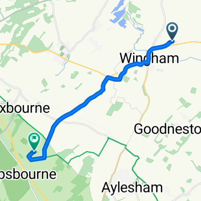
PluckGutter2Canterbury
Cycling route in Ash, England, United Kingdom
- 18.8 km
- Distance
- 70 m
- Ascent
- 59 m
- Descent


20150323_082519.gpx
Cycling route in Ash, England, United Kingdom
TEASI track
- 32.4 km
- Distance
- 117 m
- Ascent
- 116 m
- Descent

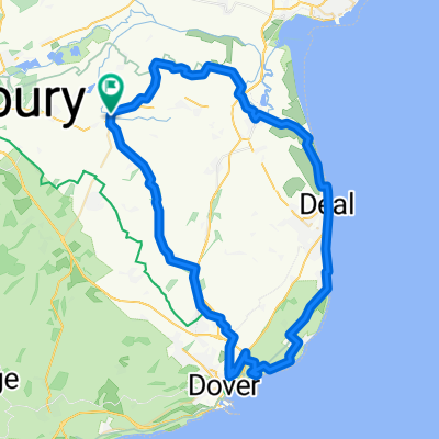
Preston - Stowting
Cycling route in Ash, England, United Kingdom
Preston - Bridge - Stowting - Bridge - Aylesham - Woodnesborough - Preston
- 87 km
- Distance
- 386 m
- Ascent
- 386 m
- Descent
Discover more routes
 Chequer Lane 43, Ash to Chequer Lane 42, Ash
- Distance
- 27.9 km
- Ascent
- 97 m
- Descent
- 100 m
- Location
- Ash, England, United Kingdom
 Easy ride in Canterbury
- Distance
- 7.2 km
- Ascent
- 36 m
- Descent
- 32 m
- Location
- Ash, England, United Kingdom
 Tuesday
- Distance
- 24.7 km
- Ascent
- 220 m
- Descent
- 216 m
- Location
- Ash, England, United Kingdom
 Relaxed route in Canterbury
- Distance
- 9.3 km
- Ascent
- 96 m
- Descent
- 44 m
- Location
- Ash, England, United Kingdom
 Kent loop 3
- Distance
- 60.8 km
- Ascent
- 258 m
- Descent
- 258 m
- Location
- Ash, England, United Kingdom
 High Street 73, Wingham to High Street 73, Wingham
- Distance
- 63.1 km
- Ascent
- 776 m
- Descent
- 777 m
- Location
- Ash, England, United Kingdom
 4 Waterworks Cottages, Adisham Road, Canterbury to 4 Waterworks Cottages, Adisham Road, Canterbury
- Distance
- 932.5 km
- Ascent
- 1,057 m
- Descent
- 1,057 m
- Location
- Ash, England, United Kingdom
 Mill Lane, Preston, Canterbury to 22 High St, Canterbury
- Distance
- 14 km
- Ascent
- 65 m
- Descent
- 67 m
- Location
- Ash, England, United Kingdom