
Cycling in Santa Barbara
Discover a map of 331 cycling routes and bike trails near Santa Barbara, created by our community.
Region portrait
Get to know Santa Barbara
Find the right bike route for you through Santa Barbara, where we've got 331 cycle routes to explore. Most people get on their bikes to ride here in the months of March and May.
18,925 km
Tracked distance
331
Cycle routes
88,410
Population
Community
Most active users in Santa Barbara


From our community
The best bike routes in and around Santa Barbara

Montecito Loop: Park Ln, Bella Vista, Viola, Toro, Coast
Cycling route in Santa Barbara, California, United States of America
Nice loop through Montecito exploring the less travelled foothill roads (both by cyclists and motorists). Viola Ln, in particular, is very secluded and, in fact, an easy (unmarked) turn to miss from Ladera Ln. As the elevation profile shows, doing this clock-wise is a lot easier than counter-cloc
- 35.2 km
- Distance
- 514 m
- Ascent
- 514 m
- Descent
Santa Barbara Triathlon - Long Course 2011
Cycling route in Santa Barbara, California, United States of America
- 56.4 km
- Distance
- 432 m
- Ascent
- 435 m
- Descent

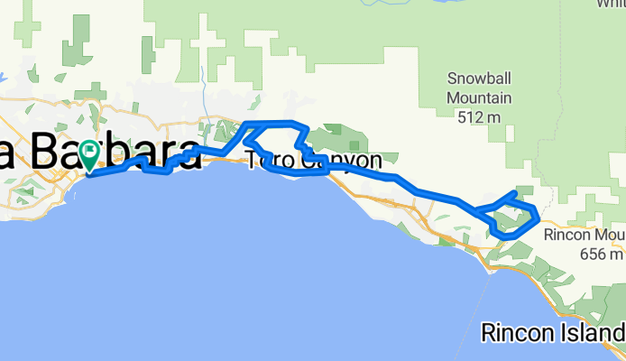
SB to Rincon Brewery
Cycling route in Santa Barbara, California, United States of America
- 18 km
- Distance
- 159 m
- Ascent
- 153 m
- Descent

CDT2010 Day 6
Cycling route in Santa Barbara, California, United States of America
Chasing Daylight Tour - Day 6
Santa Barbara (Inn by the Harbor) to Santa Monica (<span><span><span dir="ltr">Marriott-Le Merigot Beach Hotel)</span></span></span><span style="display: none;">Address:</span><span class="nw"
- 140 km
- Distance
- 261 m
- Ascent
- 252 m
- Descent
Discover more routes
 Santa Barbara to Pt Dume2
- Distance
- 109.5 km
- Ascent
- 264 m
- Descent
- 227 m
- Location
- Santa Barbara, California, United States of America
 SBA2LAX Rail + Bike ride
- Distance
- 170.8 km
- Ascent
- 334 m
- Descent
- 250 m
- Location
- Santa Barbara, California, United States of America
 Aufnahme vom 11.05.2016, 18:14
- Distance
- 22.8 km
- Ascent
- 390 m
- Descent
- 385 m
- Location
- Santa Barbara, California, United States of America
 downtown sb to cathedral peak and back
- Distance
- 37.1 km
- Ascent
- 1,207 m
- Descent
- 1,211 m
- Location
- Santa Barbara, California, United States of America
 Coronel Place 525, Santa Barbara to Coronel Place 524, Santa Barbara
- Distance
- 45.7 km
- Ascent
- 1,898 m
- Descent
- 1,642 m
- Location
- Santa Barbara, California, United States of America
 sb to los olivos
- Distance
- 58.6 km
- Ascent
- 982 m
- Descent
- 747 m
- Location
- Santa Barbara, California, United States of America
 Romeo côtes 1
- Distance
- 56 km
- Ascent
- 1,412 m
- Descent
- 1,411 m
- Location
- Santa Barbara, California, United States of America
 Mission Ridge Los Canoas
- Distance
- 17.3 km
- Ascent
- 295 m
- Descent
- 298 m
- Location
- Santa Barbara, California, United States of America