
Cycling in Stillwater
Discover a map of 92 cycling routes and bike trails near Stillwater, created by our community.
Region portrait
Get to know Stillwater
Find the right bike route for you through Stillwater, where we've got 92 cycle routes to explore. Most people get on their bikes to ride here in the months of July and August.
3,575 km
Tracked distance
92
Cycle routes
18,225
Population
Community
Most active users in Stillwater


From our community
The best bike routes in and around Stillwater
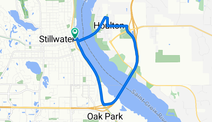
St. Croix River Crossing Loop Trail
Cycling route in Stillwater, Minnesota, United States of America
- 8.4 km
- Distance
- 123 m
- Ascent
- 123 m
- Descent

Brown's Creek State Trail, Stillwater to Brown's Creek State Trail, Stillwater
Cycling route in Stillwater, Minnesota, United States of America
- 21.4 km
- Distance
- 142 m
- Ascent
- 144 m
- Descent
68m-Stilwater-Osceola
Cycling route in Stillwater, Minnesota, United States of America
Copied from baude's Bikery Solstice century
- 110.2 km
- Distance
- 321 m
- Ascent
- 341 m
- Descent

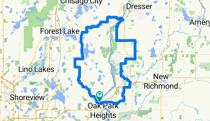
Stillwater, MN to Woodville, WI
Cycling route in Stillwater, Minnesota, United States of America
A detour on St. Croix County, Wisconsin's County Road E sent us south earlier than we had planned during an August 2008 ride from Minneapolis to Stevens Point. This section of the ride leaves Stillwater up a steep but fairly short hill, passes through farm country in rolling terrain, and co
- 52.7 km
- Distance
- 275 m
- Ascent
- 139 m
- Descent
Discover more routes
 Stillwater to Hostel Shoppe, Stevens Point, WI
- Distance
- 353.2 km
- Ascent
- 1,346 m
- Descent
- 1,225 m
- Location
- Stillwater, Minnesota, United States of America
 B2B00202 55082>55408viaHwy96,Gateway,Como,Greenway
- Distance
- 48.6 km
- Ascent
- 223 m
- Descent
- 182 m
- Location
- Stillwater, Minnesota, United States of America
 B2B00869 55082>55014 viaStillwaterRd/75thSt/GatewayTrail/WheelockPkwy/Como/EnergyPk CLONED FROM ROUTE 75356
- Distance
- 32.5 km
- Ascent
- 140 m
- Descent
- 140 m
- Location
- Stillwater, Minnesota, United States of America
 B2B00867 55082>55402 via StillwaterRd75thStN/GatewayTrail/WheelockPkwy/Como/Intercampus/4thSE/StoneArch/3rdAv
- Distance
- 41.7 km
- Ascent
- 160 m
- Descent
- 177 m
- Location
- Stillwater, Minnesota, United States of America
 BsB00144 Cty.B & Rice to Rutherford School, Stillwater
- Distance
- 23.7 km
- Ascent
- 62 m
- Descent
- 59 m
- Location
- Stillwater, Minnesota, United States of America
 Cty. B to Rutherford School Stillwater
- Distance
- 23.8 km
- Ascent
- 53 m
- Descent
- 54 m
- Location
- Stillwater, Minnesota, United States of America
 B2B00869 55082>55014 viaStillwaterRd/75thSt/GatewayTrail/WheelockPkwy/Como/EnergyPk
- Distance
- 32.5 km
- Ascent
- 114 m
- Descent
- 119 m
- Location
- Stillwater, Minnesota, United States of America
 B2B00289 55082>55455viaHwy12/GatewayTrl/Arling/WhelckPkwy/Como/Intercampus/Wash
- Distance
- 37.1 km
- Ascent
- 143 m
- Descent
- 157 m
- Location
- Stillwater, Minnesota, United States of America