
Cycling in Les Contamines-Montjoie
Discover a map of 87 cycling routes and bike trails near Les Contamines-Montjoie, created by our community.
Region portrait
Get to know Les Contamines-Montjoie
Find the right bike route for you through Les Contamines-Montjoie, where we've got 87 cycle routes to explore. Most people get on their bikes to ride here in the months of July and August.
3,511 km
Tracked distance
87
Cycle routes
1,127
Population
Community
Most active users in Les Contamines-Montjoie


From our community
The best bike routes in and around Les Contamines-Montjoie

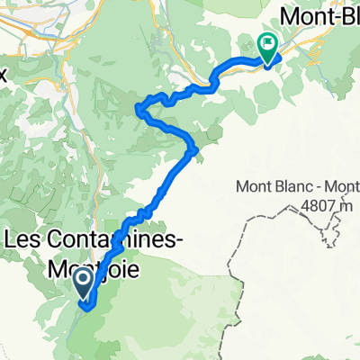
MontBlancTour3Tag
Cycling route in Les Contamines-Montjoie, Auvergne-Rhône-Alpes, France
Dritter Tag der Mont Blanc Umrundung mit dem MTB
- 32.9 km
- Distance
- 1,710 m
- Ascent
- 1,581 m
- Descent

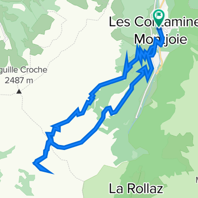
Col du Joly and l'Aguille Croche
Cycling route in Les Contamines-Montjoie, Auvergne-Rhône-Alpes, France
Superb mountain bike climb up through Les Contamines ski station to Col du Joly then much higher (2435m) to l'Aguille Croche
(cloned from route 2834265)
- 132.5 km
- Distance
- 3,011 m
- Ascent
- 2,731 m
- Descent

Col du Joly and l'Aguille Croche
Cycling route in Les Contamines-Montjoie, Auvergne-Rhône-Alpes, France
Superb mountain bike climb up through Les Contamines ski station to Col du Joly then much higher (2435m) to l'Aguille Croche
- 30.3 km
- Distance
- 1,309 m
- Ascent
- 1,309 m
- Descent

MontBlancTour4Tag
Cycling route in Les Contamines-Montjoie, Auvergne-Rhône-Alpes, France
Vierter Tag der Mont Blanc Umrundung mit dem MTB
- 52.1 km
- Distance
- 1,914 m
- Ascent
- 2,578 m
- Descent
Discover more routes
 RGA Gravel 2_Contamines-Bg-St-Maurice
- Distance
- 75.4 km
- Ascent
- 3,513 m
- Descent
- 3,847 m
- Location
- Les Contamines-Montjoie, Auvergne-Rhône-Alpes, France
 TMB 6
TMB 6- Distance
- 15.8 km
- Ascent
- 957 m
- Descent
- 1,087 m
- Location
- Les Contamines-Montjoie, Auvergne-Rhône-Alpes, France
 Day6GiteLePontetToChamonixTMB
- Distance
- 25.9 km
- Ascent
- 1,503 m
- Descent
- 2,690 m
- Location
- Les Contamines-Montjoie, Auvergne-Rhône-Alpes, France
 OLD_Day6GiteLePontetToChamonixTMB
- Distance
- 16.2 km
- Ascent
- 1,370 m
- Descent
- 781 m
- Location
- Les Contamines-Montjoie, Auvergne-Rhône-Alpes, France
 Col du Joly
- Distance
- 21.9 km
- Ascent
- 1,090 m
- Descent
- 1,095 m
- Location
- Les Contamines-Montjoie, Auvergne-Rhône-Alpes, France
 Aguille Croche via Col du Joly
- Distance
- 28.6 km
- Ascent
- 1,299 m
- Descent
- 1,300 m
- Location
- Les Contamines-Montjoie, Auvergne-Rhône-Alpes, France
 l'Aguille Croche via Col du Joly
- Distance
- 28.8 km
- Ascent
- 1,286 m
- Descent
- 1,287 m
- Location
- Les Contamines-Montjoie, Auvergne-Rhône-Alpes, France
 Tour de Mont Blanc 2017 - Etappe 4
- Distance
- 25.2 km
- Ascent
- 805 m
- Descent
- 931 m
- Location
- Les Contamines-Montjoie, Auvergne-Rhône-Alpes, France