
Cycling in Steeg
Discover a map of 101 cycling routes and bike trails near Steeg, created by our community.
Region portrait
Get to know Steeg
Find the right bike route for you through Steeg, where we've got 101 cycle routes to explore. Most people get on their bikes to ride here in the months of July and August.
7,667 km
Tracked distance
101
Cycle routes
Community
Most active users in Steeg


From our community
The best bike routes in and around Steeg


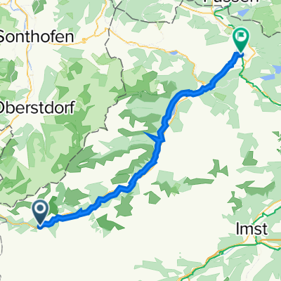
Steeg - Elbigenalp
Cycling route in Steeg, Tyrol, Austria
Fahrrad Karte Steeg - Elbigenalp 14,91km
- 14.9 km
- Distance
- 51 m
- Ascent
- 110 m
- Descent

Almajur
Cycling route in Steeg, Tyrol, Austria
von Stteg ins Almajurtal bis zur Erlach Alpe
- 27.7 km
- Distance
- 872 m
- Ascent
- 872 m
- Descent

Lechtal - Inntal
Cycling route in Steeg, Tyrol, Austria
Steeg - Hägerau
Hahntennjoch 1903m
Imst
Pillerhöhe 1558m
Prutz
- 79.6 km
- Distance
- 1,737 m
- Ascent
- 1,984 m
- Descent
Discover more routes
 Steg - Pflach
- Distance
- 55.1 km
- Ascent
- 24 m
- Descent
- 308 m
- Location
- Steeg, Tyrol, Austria
 Imst-Pitztal Bahnhof - Via Claude Augusta - Lech Radweg - Steeg
- Distance
- 108.7 km
- Ascent
- 2,022 m
- Descent
- 2,399 m
- Location
- Steeg, Tyrol, Austria
 Steeg-HolzgauHöhenweg
- Distance
- 14.2 km
- Ascent
- 421 m
- Descent
- 421 m
- Location
- Steeg, Tyrol, Austria
 Almajurtal-Erlacher Hütte
- Distance
- 31 km
- Ascent
- 857 m
- Descent
- 857 m
- Location
- Steeg, Tyrol, Austria
 Steeg-Krabachtal
- Distance
- 10.1 km
- Ascent
- 771 m
- Descent
- 124 m
- Location
- Steeg, Tyrol, Austria
 Steeg 23, Steeg nach Mühler Straße 1, Reutte
- Distance
- 52.7 km
- Ascent
- 420 m
- Descent
- 680 m
- Location
- Steeg, Tyrol, Austria
 Lechtalradweg
- Distance
- 48.9 km
- Ascent
- 92 m
- Descent
- 352 m
- Location
- Steeg, Tyrol, Austria
 Steeg - Kaiseralm (1689m)
- Distance
- 8.3 km
- Ascent
- 701 m
- Descent
- 138 m
- Location
- Steeg, Tyrol, Austria